CEDAR KEY, Fla. (AP) — Follow live updates about Hurricane Idalia, which made landfall in Florida as a dangerous Category 3 storm and later crossed into Georgia, still as a hurricane.
What to know
— Hurricane Idalia rapidly strengthened as it fed on some of the hottest water on the planet during its approach
— A rare blue supermoon was bad timing for Florida’s west coast as Idalia’s surge came ashore
— Florida’s Big Bend is one of the last truly natural places in the state — and was in the bull’s-eye of a major hurricane
Idalia remains Category 1 hurricane as it tears across south Georgia
Idalia remains a Category 1 hurricane with winds of 85 mph (140 kph) as it crosses south Georgia, the National Hurricane Center said at midday Wednesday.
The storm’s center is northeast of Valdosta, Georgia, and on a path toward the populous Savannah area.
Idalia’s fierce winds uprooted trees and sent rain flying sideways in Valdosta, near the Florida line. Video from news outlets showed a large tree toppled onto a house, an awning mangled and twisted outside a storefront, and standing water on some roads.
The White House says President Joe Biden will deliver remarks Wednesday afternoon about the federal response to Idalia.
Mayor: St. Petersburg still at risk of high water, twisters
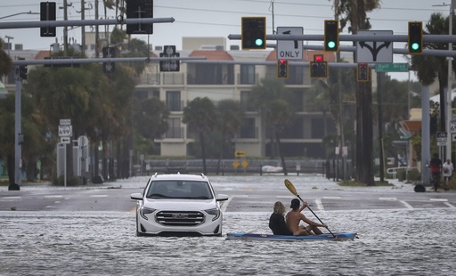
In Florida, St. Petersburg Mayor Ken Welch says parts of the city have been hit with about 4 feet (1.2 meters) of storm surge, with more water expected at high tide Wednesday afternoon.
Welch says there remains a risk from tornadoes and live downed power lines. No deaths in the city had been reported by late morning although some neighborhoods were flooded.
Three major bridges, including the Sunshine Skyway across the mouth of Tampa Bay, remained closed.
“Make no mistake, this hurricane left its mark. The reality is we are not done dealing with the consequences of this major storm,” Welch said.
Workers rush to tie down boats in Savannah, Georgia
On the Georgia coast, workers finished tying down roughly 20 sailboats and motor yachts docked at the Bull River Marina on Wilmington Island just east of Savannah.
Brandon Long, a charter boat captain and the marina’s owner, planned to shut off the marina’s fuel lines and electricity before heading inland to ride out the storm.
Long said he worried most about the 3 to 5 feet of storm surge forecast to coincide Wednesday night with a higher-than-normal high tide amplified by a full moon.
“The surge is my biggest concern,” said Long, whose marina has more than 3,000 feet of floating dock. “If these docks float off their pylons or come apart because of the violent current and the choppy waters, then that’s what destroys a marina.”
Idalia unlikely to loop back into Florida
Idalia remains a hurricane after its center crossed into Georgia with top winds of 90 mph (150 mph). Forecasters say it will punish the Carolinas overnight as a tropical storm.
It’s too soon to know what will become of Idalia after it heads out to sea, but that hasn’t stopped internet speculation that it could loop southward and make another run at Florida. Long-range models have showed a wide variety of directions, as they typically do since the forecast is so far out.
But the latest official forecast track from the National Hurricane Center, which takes into account many long-range models, does not support that theory.
The hurricane center now says Idalia will move deeper into the Atlantic and slow down as it approaches Bermuda this weekend.
There are tropical storm warnings all the way up to the North Carolina-Virginia border.
Daniel Brown of the hurricane center says strong winds are expected later Wednesday and into Thursday in the Carolinas. A threat of tornadoes will spread into eastern Georgia and eastern parts of the Carolinas overnight and into early Thursday.
Idalia’s damaging winds spread toward Georgia
The center of Hurricane Idalia is moving toward southern Georgia after passing to the east of Tallahassee, Florida.
The National Weather Service says tropical storm-force winds of 39 mph (62 kph) with a gust of 63 mph (101 kph) were reported Wednesday at the airport in Valdosta, Georgia.
On St. Simons Island, winds are picking up as the hurricane approaches on a course to rake the Georgia coast as it churns northward. During the morning high tide, waves broke over the rocks at the island’s pier, which was closed to visitors.
The island about 70 miles south of Savannah is Georgia’s most densely populated barrier island, with about 15,000 residents. It took back-to-back hits from Hurricanes Matthew and Irma in 2016 and 2017, leaving hundreds of homes with flood damage.
St. Simons Bait & Tackle was one of the few businesses open Wednesday. Though nobody was fishing, Mary Hennig had customers dropping by for snacks and coffee. She plans to close by early afternoon and head to her home on the mainland.
“I think it’ll be OK just as long as you’re definitely indoors and hunkered down when it gets close to actually hitting,” said Hennig, whose husband is one of the store’s owners.
Hurricane Idalia brings flooding to Florida streets
Hurricane Idalia is bringing flooding to the streets of Florida from Tampa to Tallahassee, a stretch of more than 200 miles (320 kilometers).
Residents in vulnerable coastal areas had been ordered to pack up and leave as Idalia gained strength. Mayor John Dailey of Tallahassee, Florida’s capital, is urging everyone to stay put Wednesday because it’s too late to risk going outside.
“The time to evacuate has come and gone,” Dailey said on NBC’s “Today” show. “It is time to shelter in place.”
In Clearwater, in the Tampa Bay area’s Pinellas County, the city is asking those who remained despite a mandatory evacuation order to restrict their water and toilet usage because the stormwater system is strained.
County officials say flooding had been reported on roads throughout coastal areas. The county sheriff’s office closed access to barrier islands, and much of Gulf Boulevard, along the barrier islands, is closed because of significant flooding.
Hurricane Idalia knocks out power
Hurricane Idalia was knocking out power in Florida after making landfall Wednesday morning. Over 200,000 customers were without power early Wednesday in the state, according to PowerOutage.us, which tracks outages nationwide. The vast majority of outages were in the state’s Big Bend region, where Idalia made landfall. Outages were expected to grow throughout the day in Florida, as well as Georgia and South Carolina.
At 8 a.m., Idalia’s eye was just inland from the coast, about 10 miles (20 kilometers) south-southeast of Perry, with top winds of 120 mph (195 kph) and moving north-northeast at about 18 mph (30 kmh).
Hurricane Idalia makes landfall in Florida as a Category 3 storm
Hurricane Idalia made landfall on Florida’s west coast as a dangerous Category 3 storm on Wednesday, unleashing life-threatening storm surges and rainfall.
Idalia came ashore in the lightly populated Big Bend region, where the Florida Panhandle curves into the peninsula. The result could be a big blow to a state still dealing with lingering damage from last year’s Hurricane Ian.
The National Weather Service in Tallahassee called Idalia “an unprecedented event” since no major hurricanes on record have ever passed through the bay abutting the Big Bend.
DeSantis urges those in Hurricane Idalia’s path to hunker down until it passes
Florida Gov. Ron DeSantis warned people in the path of Hurricane Idalia to “just hunker down until it gets past you.”
The National Hurricane Center expects storm surge to reach up to 16 feet (5 meters) in some areas of the Big Bend region, DeSantis said Wednesday at a news conference. Northeast Florida already had 11 tornado warnings and there were more possible, he said.
At 7 a.m. EDT Wednesday, Idalia was about 55 miles (90 kilometers) west of Cedar Key and 65 miles (105 kilometers) south of Tallahassee, the National Hurricane Center said. It was moving north at 18 mph (30 kph).
The U.S. Coast Guard is on standby and has pre-positioned 15 aircraft and more than 25 cutters and 20 flood response teams that are prepared to respond in the wake of the storm, Rear Admiral Douglas Schofield said. Crews flew over the western Florida area up to the Big Bend area and made call-outs to mariners to seek shelter. They’re ready to launch aircraft for urgent maritime search and rescue in the Tampa and Big Bend areas as the storm passes, he said.
Source: post


