
5:20 p.m. update
Bartholomew County remains under a Winter Storm Warning through 1 a.m. Friday. Updated snow amounts for Bartholomew County are now approximately the four (4) to seven (7) inch range between now and Friday morning. The area now has transitioned to all snow in the county, said Shannan Cooke, Bartholomew County Emergency Management director.
Winds are also beginning to increase across the area. The county will see 35 to 40 mph winds tapering off around 1 to 3 a.m. This will increase visibility issues, especially after dark, and blowing and drifting snow, Cooke said. It will be a wet and heavy snow with this storm. Keep in mind that as temperatures drop, the current wet roadway will have the possibility to freeze and create ice issues on the roadways
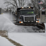
Highway crews are continue to work to clear roadways but are fighting heavy snowfall in areas along with the blowing and drifting snow. It’s anticipated that they will take a break around the late evening timeframe for rest and sleep before returning approximately 3 to 4 a.m. to begin again.
Many questions have come about regarding the release or downgrade of the current travel status from a Warning (Red) level, Cooke said. We are not anticipating the current level changing before mid-morning or later on Friday. “We will have to evaluate the conditions at that time as well as take into consideration the expected sub-zero temperatures Friday night and additional refreezing of roadways,” she said.
The county’s travel status has been upgraded to a Warning Level (Red).
Warning
The highest level of local travel advisory, means that travel may be restricted to emergency management workers only. During a “warning” local travel advisory, individuals are directed to:
(A) refrain from all travel;
(B) comply with necessary emergency measures;
(C) cooperate with public officials and disaster services forces in executing emergency operations plans; and
(D) obey and comply with the lawful directions of properly identified officers.
Closings:
County buildings are closed for Friday, February 4, with employees working remotely if possible.
City buildings, including City Hall, are closed Friday, February 4.
Cooke said emergency management has spoken with BCSC this afternoon about current conditions and expected travel status. Information will be shared when there is a decision made about plans for Friday, Cooke said.
3:45 p.m. update:
Although the Columbus area is in the middle of what might be the most severe winter storm of the season, 911 emergency calls are running about the same as they do on an average afternoon.
That’s according to Emergency Operations Center Director Todd Noblitt, who says that when a winter storm becomes this severe, the number of calls for help usually “go through the roof.”
“However, people staying off the streets today has really helped tremendously,” Noblitt said.
But with winds blowing and heavy snowfall, the main concern now switches to drifting snow that can unexpectedly cause vehicles to spin out of control.
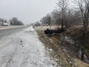
Shortly after heavy snows and strong winds moved into the area, three slide-offs were reported in northern Bartholomew County at about 2 p.m., Chief Deputy Sheriff Maj. Chris Lane said. Once again, there were no reports of injuries, Lane added.
“A lot of times, you don’t notice the drifting of snow, especially while driving at night ,” Noblitt said. “It can throw your vehicle off the roadway when you hit a big drift. Tonight, that might cause issues not only with getting stuck, but also with finding yourself confined to your vehicle during dangerously cold conditions.”
That is why so many public safety organizations and the media are stressing that drivers should have an emergency kit in their vehicles that include a fully-charged cell phone and blankets, the E911 director said.
“Tonight, it just might take a little extra time for emergency crews to get to a vehicle off the road,” Noblitt said.
Extra dispatchers have been brought in to the E911 Center to handle an anticipated rise in emergency calls, Noblitt said. The additional staff will remain until Friday, he said.
While the sleet and frozen rain has moved out of our area, Lane reminds motorists we remain under an emergency warning until early Friday morning.
“Roads will stay slick and ice-covered for several more hours,” Lane said. “So if you don’t have to go out, stay home if at all possible.”
11:30 a.m. update:
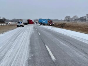
Indiana State Police troopers are on the scene of an overturned vehicle with no injuries on I-65 Southbound, just south of Seymour. Trp. Randel Miller is now conducting an Operating While Intoxicated and Drug Possession Investigation as a result of the crash.
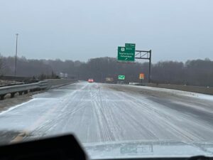
Republic photo editor Mike Wolanin provides more images of the ongoing winter storm.


11 a.m. update:
Indiana State Police report multiple jackknifed semis on I-74 westbound near the 125 mile marker in western Decatur County has I-74 westbound shut down. Traffic is being diverted off of I-74 at the 132 mile marker near Greensburg.
10:40 a.m. update:
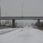
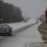
A cold wintry mix of sleet and snow pummeled Bartholomew County Thursday leading officials to declare the county at warning level “red” and restricting travel to emergency workers only.
The National Weather Service listed the county in a winter storm warning through 1 a.m. Friday, predicting snow amounts of up to 7 inches and as much as 1/10th of an inch of ice coating the area.
The heaviest snowfall was expected to fall by Thursday night and tapering off between 2 and 5 a.m. Friday.
To add to the misery, Bartholomew County was predicted to receive 35 mph to 40 mph winds, decreasing visibility and causing the likelihood of blowing and drifting snow.
County and city road crews had the additional challenge of not being able to pretreat roads due to Wednesday’s heavy rainfall, leading to a coating of ice, that was then covered with mixed precipitation and then snow.
Since the county’s travel warning remains under red, only emergency vehicles and those who provide medical and first-responder services should be on the roads at this time, Bartholomew County Emergency Management Director Shannan Cooke said. Besides the city and county crews, there are also several private contractors and individuals with snow plows out trying to clear roads and streets, she said.
Cooke said there were reports of a couple of factories disregarding the warning status and requiring their employees to come in.
In addition, a few retailers have opened their stores, and while the number of vehicles out on the roads and streets is greatly reduced from normal, there is traffic out on the roads, Chief Deputy Sheriff Maj. Chris Lane said. While several four-wheel patrol vehicles are out, no vehicles are being pulled over for ignoring the travel warning, he said.
“But I think the majority of drivers are staying in,” Lane said. “We didn’t have too many slide-offs this morning.”
Indiana State Police worked an accident early this morning near the 76 mile marker of Interstate 65, but Cooke said she had no further details.
On the county roads, an accident this morning occurred shortly before 5 a.m. on Lowell Road, just east of the Lowell Bridge. It happened when a truck hauling a trailer slid off the road, Lane said. There were no injuries, and the road was reopened at 6:37 a.m., he said.
There have been no accidents involving injuries investigated by the Bartholomew County Sheriff’s Department as of 10 a.m., Lane said.
“There was so much notice that this was coming that I think people had prepared themselves,” Lane said.
“But the driving conditions are only going to get worse as the day goes on,” Cooke said.
10 a.m update: Duke Energy provides updated information as wintry mix continues falling in Columbus
PLAINFIELD – Duke Energy said predicted heavy snow and freezing rain from today’s winter storm are likely to cause widespread power outages throughout Indiana.
In advance of the storm, Duke Energy staged nearly 1,500 workers – power line technicians, damage assessors and vegetation workers – across its service area.
Those workers include Duke Energy crews normally based in North Carolina and South Carolina who traveled to Indiana to assist locally based crews.
“We brought in extra crews before the storm to ensure we had ample resources to restore our customers’ power as quickly as possible,” said Kevin Morgan, Duke Energy’s general manager for emergency preparedness. “These crews more than doubled the number of workers we normally have available. Our teams are ready to restore power as soon as weather conditions safely allow.”
The storm’s severity and hazardous road conditions could delay crews’ ability to begin power restoration in the hardest-hit areas, extending the duration of power outages for some customers.
Heavy, wet snow of 6 inches or more can cause trees and branches to fall on power lines, as can ice-buildup due to freezing rain – both resulting in power outages.
Duke Energy urged customers to make alternative housing arrangements in case they lose power during what is predicted to be a multi-day period of extremely cold temperatures. Households that have elderly residents or individuals with special medical needs are especially urged to make such arrangements.
Power restoration process
Following the storm, as conditions allow, damage assessment crews will assess the extent of damage – which can sometimes take several hours after major storms that cause widespread damage and dangerous driving conditions.
Damage assessments determine the types of crews, equipment and supplies needed to restore power in specific areas.
Simultaneously, other crews will begin repairs in certain areas, as conditions allow.
Some customers might experience more than one power outage, depending on the storm’s severity and the power restoration process in specific, heavily impacted areas.
Duke Energy will provide estimated power restoration times as soon as those times are determined.
The company also will provide regular updates to customers and communities through emails, text messages, outbound phone calls, social media and its website, which includes power outage maps.
- Duke Energy on Twitter: twitter.com/DukeEnergy
- Duke Energy on Facebook: facebook.com/DukeEnergy
Duke Energy serves 860,000 customers in Indiana.
How to report power outages
Customers can report power outages by texting “OUT” to 57801 or by calling 800.343.3525.
Customers also can report outages online at duke-energy.com/outages or through the Duke Energy mobile app.
Sign up for outage alerts
Customers can receive the most up-to-date information about power restoration efforts by enrolling in Outage Alerts.
Winter storm safety reminders
- Stay away from power lines that have fallen or are sagging. Consider all lines energized as well as trees or limbs in contact with lines. Please report downed power lines to Duke Energy or local emergency services.
- If a power line falls across a car that you’re in, stay in the car. If you MUST get out of the car due to a fire or other immediate life-threatening situation, do your best to jump clear of the car and land on both feet. Be sure that no part of your body is touching the car when your feet touch the ground.
- If you use a generator due to a power outage, follow the manufacturer’s instructions to ensure safe and proper operation. Operate your generator outside; never operate it inside a building or garage.
- Don’t use grills or other outdoor appliances or equipment indoors for space heating or cooking, as these devices may emit carbon monoxide.
More tips on what to do before, during and after a storm can be found at duke-energy.com/safety-and-preparedness/storm-safety. A checklist serves as a helpful guide, but it’s critical – before, during and after a storm – to follow the instructions and warnings of emergency management officials in your area.
Avoid customer scams
Customers should be alert to scammers who might call them – impersonating Duke Energy representatives and threatening to cut off customers’ power before or during the storm unless customers make an immediate payment for late bills or other charges.
Duke Energy never makes such calls.
Below are tips for customers to avoid such scams:
- If it’s a recorded voice, often referred to as a “robocall,” be extra cautious.
- Do not provide any personal information.
- Duke Energy’s actual recorded calls to customers are informative only. The company’s calls never threaten to cut off power and never request personal information.
- If a caller – recorded or live – specifically asks you to pay using a prepaid debit card, that’s a red flag. Prepaid debit cards are like cash and the transactions cannot be reversed.
- If the caller pressures you to make an immediate payment of any type – or provide personal information of any kind, such as a bank account number or social security number – hang up the phone.
9 a.m. Thursday update:
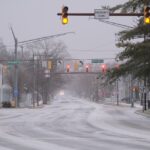
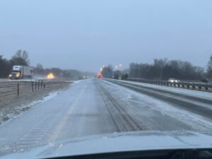
Republic photo editor Mike Wolanin provides images of road conditions this morning in Columbus as a wintry mix continues to fall and streets remain slick and ice-covered.


6:45 a.m. Thursday update:
Statement from Shannan Cooke, Bartholomew County Emergency Management Director:
Bartholomew County remains under a Winter Storm Warning through 1 a.m. Friday. Updated snow amounts for Bartholomew County are now approximately the four (4) to seven (7) inch range with one-tenth (.10) of an inch of ice total.
Timing for the transition from our current freezing precipitation to all snow is expected approximately 9 to 10 a.m. this morning. Heaviest snowfall will come between 10 a.m. and 6 p.m. before we see it begin to taper off. We should see snow ending between 2 and 5 a.m. Friday morning.
There still seems to be some uncertainty remaining in details regarding exact types and amounts south of I-70 from the National Weather Service with the potential of significant changes in precipitation type and amount with the smallest change in track on direction or another.
The county can still expect 35 to 40 mph winds between 7 a.m. and 7 p.m. on Thursday, increasing chances for visibility issues and blowing and drifting snow. It is a wet and heavy snow with this storm. Remember, highway crews were not able to pretreat roadways due to the rainfall prior to the freezing precipitation and snow with this system but all crews ae out now working to treat them.
The county’s travel status has been upgraded to a Warning Level (Red).
Warning
The highest level of local travel advisory, means that travel may be restricted to emergency management workers only. During a “warning” local travel advisory, individuals are directed to:
(A) refrain from all travel;
(B) comply with necessary emergency measures;
(C) cooperate with public officials and disaster services forces in executing emergency operations plans; and
(D) obey and comply with the lawful directions of properly identified officers.
Thursday, 6:30 a.m. update
Statement from Shannan Cooke, Bartholomew County Emergency Management Director:
Bartholomew County roadways are slick and dangerous and are going to deteriorate throughout the day with more ice and snow expected. Bartholomew County has upgraded the county’s travel status to an Warning Level (Red).
For this level:
Warning
- The highest level of local travel advisory, means that travel may be restricted to emergency management workers only. During a “warning” local travel advisory, individuals are directed to:
- (A) refrain from all travel;
- (B) comply with necessary emergency measures;
- (C) cooperate with public officials and disaster services forces in executing emergency operations plans; and
- (D) obey and comply with the lawful directions of properly identified officers.
5:30 p.m. update Wednesday
INDIANAPOLIS — Approximately 240 Indiana National Guardsmen responded to the governor’s call to assist state and local civil authorities to prevent the loss of life due to severe winter weather conditions throughout the Hoosier state.
From Indiana Department of Homeland Security guidance, citizen-soldiers will man command and control nodes in the northern, central and southern parts of the state as well as form highway assistance teams to help stranded motorists.
A total of 60 highway teams will assist along Hoosier highways with 20 in the northern part of the state, 20 in the central and 14 in the south, with an additional six ready to move to areas of the state with extreme weather impacts.
The Hoosier Guardsmen will be based in their armories throughout the state: South Bend, Lafayette, Gary, Fort Wayne, Lawrence, Terre Haute, Richmond, Camp Atterbury, New Albany, Evansville, Bloomington and Scottsburg.
All Hoosiers are advised to stay off the roads and remember to call 911 for assistance if stranded on the roadway.
4:49 p.m. update
Bartholomew County Emergency Management Director Shannan Cooke released new details about the pending winter storm.
Bartholomew County remains under a Winter Storm Warning through 1 a.m. Friday. Updated snow amounts for Bartholomew County are now approximately the four (4) to six (6) inch range with one-tenth (.10) of an inch of ice.
Timing for the transition from our current rainy conditions to freezing precipitation is expected at approximately 8 to 9 p.m. Wednesday night.
Freezing rain, mainly sleet or with freezing rain mixed in, will occur from 9 to 10 a.m. Thursday before it transitions to all snow, Cooke said. Heaviest snowfall will come between 10 a.m. and 5 p.m. before the snow begins to taper off. Snow should end between 2 a.m. and 5 a.m. Friday.
There still seems to be some uncertainty remaining in details regarding exact types and amounts south of I-70 from the National Weather Service. This system has the potential of significant changes in precipitation type and amount with the smallest change in track on direction or another, she said.
Bartholomew County can still expect 35 to 40 mph winds between 7 a.m. and 7 p.m. on Thursday. This can increase our chances for visibility issues and blowing and drifting snow. It is a wet and heavy snow with this storm, she said.
Keep in mind that as temperatures drop and our transition begins from rain to freezing precipitation, the current wet roadway will have the possibility to freeze and create ice issues on the roadways. Highway crews were not able to pre-treat roadways due to the rainfall prior to the freezing precipitation and snow with this system.
County and city highways crews currently plan to start their crews at 7 a.m. on Thursday since this will be a prolonged event.
Further updates are planned.
4 p.m. update
Local officials had their eye on approaching weather Wednesday as residents braced for an expected overnight winter storm bringing freezing rain, sleet and snow to the county.
Bartholomew County Emergency Management Director Shannan Cooke updated predictions on the weather on Wednesday saying the National Weather Service has lowered the amount of snowfall expected south of I-70, but the path of the storm was still uncertain.
“Keep in mind that we could possible still see pockets of higher amounts and any further shift could change the snowfall amounts yet again,” Cooke said.
Rain was expected to switch over to sleet and freezing rain at about 9 p.m. Wednesday, and then switch over to all snow. Many parts of northern Indiana were in the snow zone for most of the day Wednesday and were reporting heavy, wet snow blanketing areas north of Indianapolis.
Winds in the range of 30 to 35 mph are expected this morning, through the afternoon, which could affect visibility and road conditions, Cooke said. Motorists are asked to check your county’s travel status at at https://www.in.gov/dhs/traveladvisory/ before attempting to venture out today.
As of Wednesday afternoon, Bartholomew Consolidated School Corp. said school officials were monitoring the weather forecast. All games for Wednesday night were canceled, per a social media post from the district. Practices and extracurriculars were to “remain on schedule until 7 p.m. (Wednesday).”
Learning devices were being sent home Wednesday in the event BCSC called an eLearning day today.
If officials decide to delay or close schools, a decision will be communicated as soon as possible and no later than 5:30 a.m. today, school officials said. Communication will take place via BCSC’s eAlert system, social media and website, as well as local news outlets.
If school is closed, students will take part in eLearning. Meals are not provided during an eLearning day; neither is iCare.
Indiana Gov. Eric Holcomb urged Hoosiers to use caution as a multiagency response was being mounted to respond to the storm and its aftermath, which he said will likely last three to four days.
Holcomb implored Hoosiers to avoid travel if possible and to “use common sense” if they do venture out onto the roads. He urged residents not to “over do it” when it comes to shoveling, and to check on neighbors, especially if power outages occur.
“We have the resources to weather this storm. What we really need is cooperation. Stay safe,” Holcomb said during a Wednesday news conference.
Indiana Department of Transportation commissioner Joe McGuinness noted that road crews will not be able to pretreat roads as much as they would like due to rain that’s expected to fall just before the snow and ice arrives.
Officials said 54 Indiana National Guard teams will be out to rescue stranded motorists, but Indiana State Police Superintendent Doug Carter called on Hoosiers “to stay off the roads.”
Up to a foot of snow was forecast to fall by late Thursday or early today over much of the northern half of Indiana, with several inches of snow predicted for central Indiana and moderate to heavy ice accumulations forecast over southern Indiana.
9 a.m. update
Statement from Bartholomew County Emergency Management Director Shannan Cooke:
“It appears that snowfall amounts have trended downward across areas south of I-70. However, keep in mind that we could possible still see pockets of higher amounts and any further shift could change the snowfall amounts yet again. In addition to this we are still expecting the rain today to switch over to a sleet and/or freezing rain mixture, starting approximately 9 p.m., before fulling switching over to snow. We are also expecting winds in the range of 30 to 35 mph tomorrow morning through the afternoon that could have an impact on visibility and road conditions. Prepare to allow extra time for travel in the morning if you have to go somewhere and make sure that you check the county’s travel status at https://www.in.gov/dhs/traveladvisory/.”
ORIGINAL STORY
Bartholomew and surrounding counties are now under a winter storm warning from tonight through late Thursday, with hazardous conditions affecting the morning or evening commute on Thursday.
The National Weather Service also issued winter storm warnings for areas north of I-70 from 7 a.m. Wednesday morning to 1 a.m. Friday morning.
Columbus officials are expecting rain, snow, sleet and ice over the next few days, and department heads met Tuesday morning to discuss the storm. Columbus Mayor Jim Lienhoop said the city is planning for a “significant amount” of precipitation and will see what happens.
“Bryan Burton, who runs our Department of Public Works, emphasized to us that the current thought is that this storm will develop slowly,” he said at Tuesday’s Board of Works meeting. “It will start out as rain, and then as temperatures fall, it will divert to sleet and ice, and then we may get some snow.”
The precipitation that was anticipated to begin as rain and continue into Thursday night will limit the amount of preventative measures that can be provided by road and street crews. The predicted rain means street and highway departments will not be able to put down brine – a liquid solution containing about 22% salt and 78% water intended to prevent snow and ice from sticking to the road – because the rain would just wash it off the pavement.
“We can’t do anything in advance with this type of storm,” Executive Director of Public Works and City Engineer Dave Hayward said.
“It is going to be the first big storm for us this year, so please have patience and give our plow drivers plenty of room to work,” said Burton.
Bartholomew County Emergency Management Director Shannan Cooke said Tuesday afternoon that snowfall totals for the county are now estimated in the 8-inch range for the northern portion and 6 to 8 inches for the southern portion.
Winds will be a factor in this storm with north to north-east winds gusting at 30 to 40 mph beginning late Thursday morning through Thursday afternoon.
Near blizzard conditions could be possible in some areas with heavy rates of snowfall, 1 to 2 inches per hour, along with the winds, Cooke said.
The city will monitor the situation, and personnel from public works, parks and Columbus City Utilities will be on call over the weekend.
In Columbus, officials are asking the public to pay attention to announcements such as road closings or city closings, said Director of Administration and Community Development Mary Ferdon.
At this time, it appears the rain will begin changing to sleet, ice and snow between 1 a.m. and 4 a.m. on Thursday, according to Bartholomew County Emergency Management Director Shannan Cooke.
Besides plowing, the only step that can be done during the winter storm is to put some sand down with the salt to give vehicles some type of traction, Cooke said.
“If the weather gets bad and you don’t have to travel, then don’t,” said Ferdon.
Duke Energy is anticipating a snow band just north of Indianapolis that could receive upwards of 12 inches, Duke spokesman Chip Orben said.
While snow is impactful, ice and sleet are clearly tougher on electrical systems, Orben said. While forecasters say ice accumulations of around one tenth of an inch could occur in the Columbus area Thursday, it’s usually when a quarter-inch or more of ice builds up that downed power lines and tree limbs begin falling, according to the National Weather Service.
But since there remains some uncertainty on the path of the storm that could impact precipitation types and amounts, city and county officials are warning against anyone letting down their guard.
“That storm could slip further south than expected and that changes everything,” Orben said.
Blowing snow could also be a problem on Thursday, with wind gusts of up to 25 miles per hour anticipated, he said.
If the storm does become severe, steps may be taken such as making sure four-wheel drive vehicles accompany all ambulance runs, as well as additional 911 dispatchers being called in to handle the extra dispatching to emergencies, Cooke said.
Duke Energy, which serves 69 of Indiana’s 92 counties, will send crews out Wednesday night to stage areas, which are areas of the state where the worst impact of the winter storm is anticipated, Orben said. But if the storm causes more damage than expected in Bartholomew County, a number of electrical contractors will be deployed as needed, Orben said.
INDOT will be at a full call with nearly 1,000 trucks treating and plowing highways across the state beginning overnight Tuesday into Wednesday morning, according to state officials. INDOT is urging motorists to stay off the roads and avoid unnecessary travel to allow plow truck drivers room to work safely and so they may complete their routes as quickly as possible.
All precipitation is expected to move out of this area, resulting in calmer winds, by 1 a.m. Friday. With sunshine and a high in the 20s, road treatments are expected to be far more effective on Friday.

Photo provided Columbus Department of Public Works employees Craig Bartlett, left and Kurt Carlson work on a salt truck in preparation for the upcoming ice and snow storm.

Photo provided Columbus Department of Public Works employees Tim Morris, left, and Jack Piercefield work on preparing a salt truck for the upcoming ice and snow storm on Tuesday.

Photo provided City of Columbus salt and plow trucks are shown at the city’s Department of Public Works on Tuesday.


