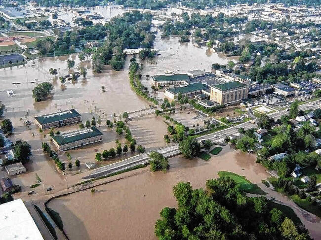
Living with flooding comes with the territory if you’re a Hoosier. And that is particularly true here in south central Indiana, where the convergence of deceptively small, quick rivers, creeks and tributaries can give rise to deadly flooding terribly fast.
The Republic on Sunday shared your stories recalling the historic flooding of 2008, which was 15 years ago this week. Three county residents died in those floods, and property damage was more than half-a-billion dollars. Columbus was the hardest hit community in a federal disaster area that was declared just one day after rising water left about 15% of the city’s structures damaged by flooding.
As we looked back on some of the worst local flooding anyone can remember, it was also an opportune moment to look forward in view of what has changed.
Our community has made progress. We are better prepared for a historic flood than we were in 2008. And in terms of prevention, significant strides have been made.
Frankly, living through that historic flood gave local officials and emergency responders new awareness of the importance of preparation, prevention and public safety. As disasters go, 2008 was a perfect storm of relentless heavy rainfall on saturated ground that shed into local waterways, rising with alarming speed.
“I don’t think any of of us quite expected what we got. It was catastrophic,” Bartholomew County Emergency Management Director Shannon Cooke, who was deputy director at the time of the flood, told The Republic’s Andy East.
As East reported, several things happened as a result of the 2008 flood. Among them:
- Community Regional Health — which was forced to evacuate for the first time in its history — and Cummins Inc. partnered to fund their own floodplain study of Haw Creek. The Federal Emergency Management Agency also remapped this floodplain.
- CRH constructed a $4.7 million floodwall around the hospital campus with the help of FEMA to prevent future flood damage. The floodwall was built 2 feet higher than the 100-year flood elevation and includes 15 floodgates at entry points to the hospital campus.
- City officials decided to increase local planning regulations governing the most sensitive part of floodplains and protect the area from development.
- Stream gauges were installed and more added along major bodies of water, including Haw Creek, where there were no flood gauges at the time of the 2008 flood. These gauges measure water levels in several creeks and rivers, giving officials real-time readings that can warn of rising water.
- The Everbridge system allows officials to send messages to residents by phone, text and email alerting them to dangerous conditions — a service emergency officials lacked 15 years ago. Everbridge also can be used to share communications internally among emergency personnel.
The best teacher is experience, and the lesson of the 2008 flood is that massive catastrophe can happen here with little advance warning. That said, it’s encouraging to know that local leaders, planners, emergency responders and citizens have heeded the lessons and planned accordingly.
As a result, we are better prepared to plan for, watch for, respond to and recover from the next big flood.


