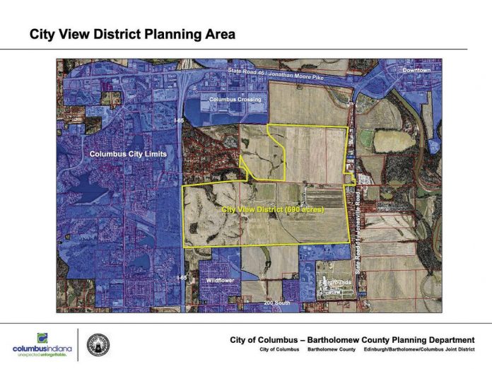
Graphic provided A view of the planning area for the Columbus Regional Health development on Columbus’ west side.
Columbus Regional Health and the city of Columbus have presented a concept to turn a nearly 700-acre, hospital-owned site west of Columbus into a hub of new development including a hospital campus, housing options and a great deal of green space.
A draft plan for the property, referred to as the “City View District, may be accessed at columbus.in.gov/planning/columbus-current-projects/.
The site, also known as the Garden City Farms property, stretches east-to-west from Interstate 65 almost to State Road 11/Jonesville Road, and is south of the westside Walmart and north of the Bartholomew County 4-H Fairgrounds.
Members of the public are invited to attend an open house on the draft plan May 31 at NexusPark. Community members may drop in any time between 6 and 8 p.m. and will be able to learn more about the plan and provide input. There will be a brief presentation of the draft plan at 6:45 p.m., officials from CRH and the city of Columbus – Bartholomew County Planning Department said.
“With CRH intending to retain only a portion of the property, the remainder provides the possibility of adding future housing, jobs, and amenities to the community, but only with careful consideration of the property’s limitations, including flood hazards,” the planning department’s website states. “The future development of the property also provides the opportunity for new street and trail connections, utility corridors, and other infrastructure envisioned by the City of Columbus Comprehensive Plan.”
The “City View District Plan” is intended to serve as a master plan to guide CRH’s decisions regarding the site. City officials are considering adopting the proposal as an element of the city’s Comprehensive Plan, which provides guidance for future land use and development in the community.
In addition to a future health care facility, the draft plan proposes a variety of residential neighborhoods, commercial centers, and a research and development campus. These areas would be connected to each other and nature via “open spaces, green corridors, and amenities that extend throughout the property,” officials said.
“The plan envisions pedestrian-friendly neighborhoods connected by a mobility network including bike lanes, on-street parking, crosswalks, pedestrian paths and landscape enhancements that encourage walkability to green spaces,” the draft plan states. “The plan also establishes a new model for urban living with higher density residential choices with ease of access to convenience, entertainment and shopping. It will provide a renewed emphasis on improved health benefits to residents and visitors through enhanced connections to nature.”
The concept includes a north-south roadway that connects with Morgan Willow Trace and cuts through the site, with a 100-acre CRH campus just east of the road, close to the northern-most edge of the site. By comparison, CRH spokeswoman Kelsey DeClue said that the hospital’s 17th Street campus is about 32 acres.
There are also plans for residential areas of differing densities, with the highest density housing being closest to the hospital, the medium density a little further west, and the low density being on the far western edge of the site, near I-65.
Other concepts for the property include mixed use developments, retail, “civic” uses, a 150-key hotel, senior housing, medical office buildings and office space.
The draft plan also states that part of the site includes a historic family cemetery, which should be left undisturbed and preserved.
City/county planning director Jeff Bergman said in a previous interview that the property is not currently within Columbus city limits, and annexation would be a prerequisite to its development.
Additionally, there are some potential challenges to developers. According to the draft plan, portions of the planning area are within the 100-year flood elevation, as mapped by the Federal Emergency Management Agency, and there is a designated floodway in the northeast corner of the planning area, which would constrain development.
Out of the approximately 690-acre site, 220 acres are in 100-year floodplain, 112 are in 500-year floodplain and 44 are in floodway. These areas mainly occur in patches on the east and north sides of the site.
Under the concept plan, the following developments are shown as potentially being in or around flood hazard areas: some natural areas, a “North Gateway Area”, the CRH campus, a few different parks, a “Mixed-use Village Center,” a research and development campus, a townhouse neighborhood/high-density development, and a “recreation park and maintenance facility.”
“After consulting with the design team’s engineer, it was determined that the floodplain and floodway are likely inaccurate, and would require additional modeling to accurately map the floodplain and floodway limits,” the draft plan states. “Preliminary analysis indicated that much of the area currently showing as being impacted by the floodplain would, in fact, be developable. This led to the reclassification of the developable lands summary into 3 categories: developable, developable with constraints, and undevelopable.”
The plan estimates that after accounting for possible flood hazard areas and other factors, 37% (253 acres) of the land is developable, 54% (376 acres) is developable with constraints, and 9% (61 acres) is undevelopable.
Another factor in potential development is that much of the property is within the Wellfield Protection Overlay District, which was established by the city of Columbus as a safeguard for residents who use utility-operated wellfields for drinking water.
“These safeguard zones establish how long it would take a harmful substance to reach the wellfield upon infiltration within the boundary,” the plan states.
Much of the site is identified as being in an area where it would take five years for this to occur, though there is also a sizeable portion to the southeast that is in a one-year zone. There are several wellfields south of the site.
CRH purchased the property from the Stadler family in 2018. While hospital officials had been looking for a 100 to 150 acre-site for a new or expanded health campus, the Stadlers did not want to sell their 800 acres of farmland in smaller parcels, CRH president and CEO Jim Bickel said in a previous interview. The two parties eventually reached an agreement wherein the hospital would buy the whole site for about $11 million and sell about 100 acres back to members of the family who wished to retain part of the land.
Since the hospital still ended up with more land than they needed, they decided to work with local stakeholders to look at the future of the property.
“Shortly after Columbus Regional Health acquired the land in 2018, a multidisciplinary Land-Use Planning Committee was launched to create a vision for the property,” CRH officials said. “The committee — comprised of CRH, city and county government, city planning and engineering departments, and economic development — engaged Design Workshop, an international architecture, economics and urban design firm, to guide the process and conduct a market study.”
Bickel said that as they went through the process, officials sought to determine where CRH might locate a “future health campus” on the site, as well as what community needs could be met with the rest of the acreage.
CRH then spoke to city officials about the next steps of formalizing the vision for the site, which led to a discussion about the possibility of adopting a “comprehensive master plan” for the site and incorporating it into the city’s Comprehensive Plan.
The Comprehensive Plan is a long-term statement of a community’s vision for its future, according to the city’s planning department. The plan provides goals, policies, and other guidance for future land use and development.
The Comprehensive Plan is a separate document from zoning and subdivision control ordinances. It is intended to influence, but not mandate, community land use and development decisions.
In order to be adopted as an element of the city’s Comprehensive Plan, the City View District Plan must first be reviewed by the Columbus Plan Commission, then be approved by the Columbus City Council.
“The public will have an opportunity to participate at these future meetings as well,” said city and CRH officials.
According to the draft of the City View District Plan, collaborators in the planning process have included CRH, Columbus, Bartholomew County, the Greater Columbus Economic Development Corp., the city/county planning department, the city engineer and Department of Public Works, Design Workshop, S&ME, Inc with WSP, Columbus City Utilities, Strand Associates, the Garden City Mobile Home Community and Administrative Resources association.
CRH officials have emphasized that they are looking at a long-term timeline for developing the westside property.
“This is a multi-decade sort of evolution,” said Vice President of Strategic Facilities Planning and Operations David Lenart in a previous interview. “Nothing’s going to happen in a couple of years.”


