
Mike Wolanin | The Republic A view of the snow fall on 19th Street in Columbus, Ind., Friday, Jan. 19, 2024.
9:36 p.m. update
The county’s travel status has been upgraded to a Warning Level (Red). Road conditions have deteriorated and travel is now restricted to emergency personnel/situations only.
Warning (Red)
The highest level of local travel advisory, means that travel may be restricted to emergency management workers only. During a “warning” local travel advisory, individuals are directed to:
- Refrain from all travel;
- Comply with necessary emergency measures;
- Cooperate with public officials and disaster services forces in executing emergency operations plans; and
- Obey and comply with the lawful directions of properly identified officers.
Additional exceptions to the warning travel advisory are found in Indiana Code 10-14-3-29.
County travel status levels can be checked at https://www.in.gov/dhs/travel-advisory-map/.
Check state highway road conditions at https://511in.org.
6 p.m. update
Bartholomew County’s travel status has been upgraded to a Watch Level (Orange). Moderate snowfall continues to fall with heavier bands moving toward the Bartholomew County area. Visibility is expected to decrease as a result of both the heavier snowfall and darkness. Please refrain from travel unless absolutely necessary.
Watch (Orange)
Means that conditions are threatening to the safety of the public. During a “watch” local travel advisory, only essential travel, such as to and from work or in emergency situations, is recommended, and emergency action plans should be implemented by businesses, schools, government agencies and other organizations.
County travel status levels can be checked at https://www.in.gov/dhs/travel-advisory-map/.
5:20 P.M. UPDATE
The National Weather Service has told Bartholomew County Emergency Management that moderate snow and potential for decreased visibility is possible with this latest band of snow. The county’s travel status is currently at an Advisory Level (Yellow) but is anticipated be increased to a Watch Level (Orange) as snow continues to fall and visibility is decreased, according to emergency management.
11:30 A.M. UPDATE
Bartholomew County’s travel status has been upgraded to an Advisory Level – Yellow. Please use caution if you travel. Allow extra time to reach your destination. Increase the distance to stop and between you and other vehicles.
Advisory
The lowest level of local travel advisory, means that routine travel or activities may be restricted in areas because of a hazardous situation, and individuals should use caution or avoid those areas.
County travel status levels can be checked at https://www.in.gov/dhs/travel-advisory-map/.
Check state highway road conditions at https://511in.org.
ORIGINAL STORY
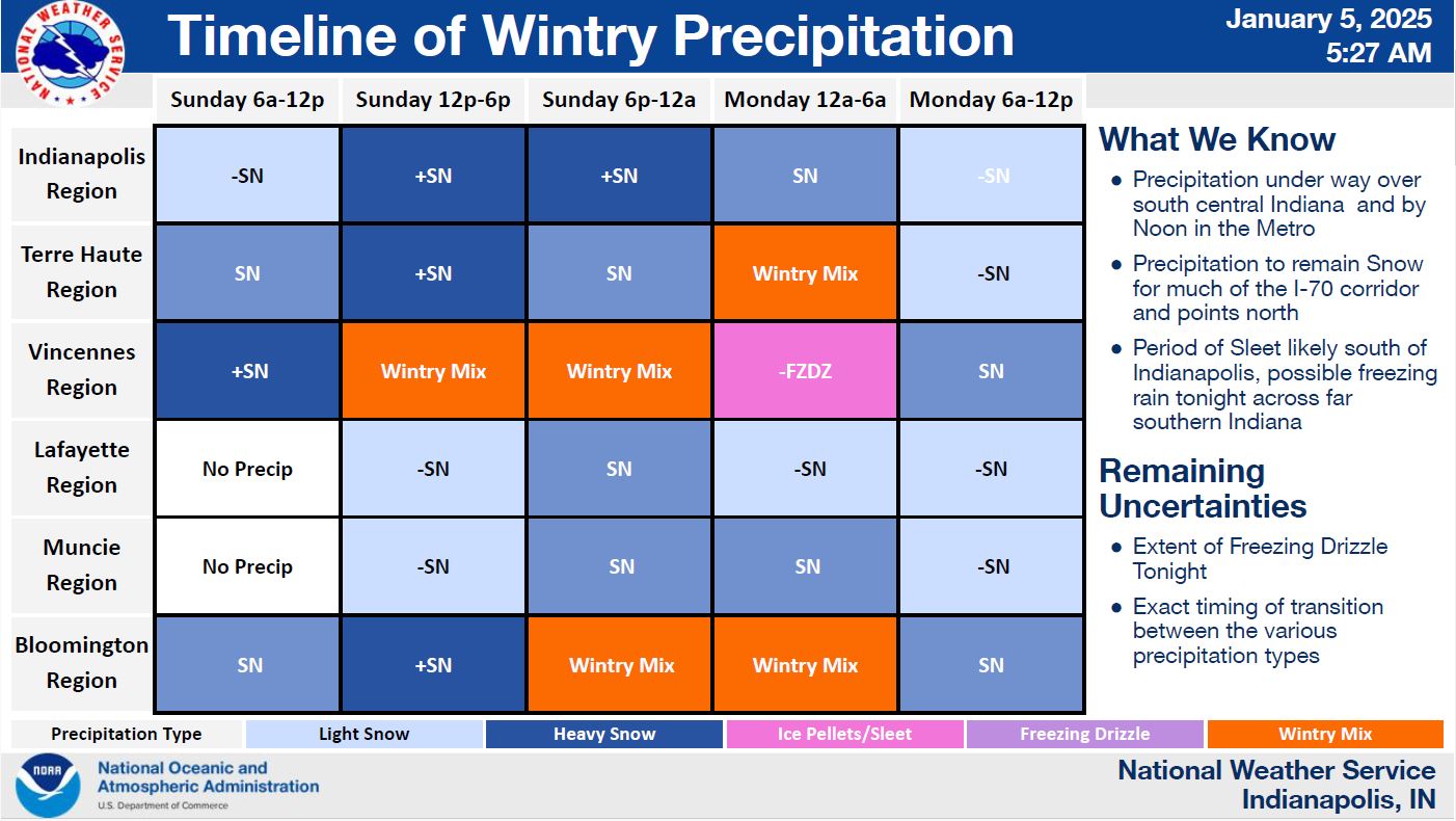
COLUMBUS, Ind. — Bartholomew County Emergency Management said Sunday morning that the winter storm warning remains in effect for Bartholomew County until 7 p.m. Monday. A track change as little as 10-20 miles can still significantly affect the impacts of the storm for any location. While the snow and wintry mix is expected today and Monday, the road and travel impacts will likely remain later in the week due to the extreme cold temperatures.
Key Messages:
- 5 to 11 inches of snow and ice accumulations up to 0.10 inch are expected.
- Ice/sleet is expected to mix in across south-central Indiana this evening and overnight with light accumulations possible.
- Winds gusts between 30-40 mph tonight into Monday morning.
- Much colder temperatures arrive in the wake of the winter storm with multiple days of sub-zero wind chills likely. Wind chills as low as -10° at times.
- Wind and snow may reduce visibility.
Timing:
- Winter Storm Warning
- Moderate Snow – Sunday noon to 6 p.m.
- Wintry Mix – Sunday 6 p.m. to Monday 6 a.m.
- Moderate Snow – Monday 6 a.m. to 2 p.m.
- Strong wind gusts – Monday
- Single digit wind chills to -10° – Coldest mornings expected Thursday and Friday mornings.
Main Threats:
- 5 to 11 inches of snow expected. Some pockets of up to 12 inches of snow.
- 0.01” to 0.1” if total ice accumulation possible.
- Trees and power lines could be knocked down due to wind and weight of snow/ice.
- Expect widespread travel impacts.
- Single digit and below zero wind chills expected.
- Bitter cold temperatures extending through the middle of January.
Actions/What To Do:
- Be weather aware.
- Continue to monitor the weather through your local trusted weather stations.
- If you do not have to travel, stay home.
- If you must travel, slow down, drive carefully, and allow extra time to reach your destination.
- Ensure your vehicle is full of gasoline/fuel.
- Clear snow and ice from vehicle windows before traveling.
- Keep an emergency kit in your vehicle.
- If you must be outdoors, dress in layers and limit time outside.
- Take frequent breaks if shoveling snow.
- Ensure pets have appropriate shelter and bedding if they cannot be brought indoors.
- Properly vent emergency heat sources.
- Keep generators at least 20 feet from your home.
- Check on family and neighbors.
- Avoid calling 911 and emergency services for non-emergencies.
- Monitor the Statewide Travel Advisory Map at https://www.in.gov/dhs/travel-advisory-map/ for the latest travel status by county.
- Check statewide, state road, road conditions at https://511in.org .


