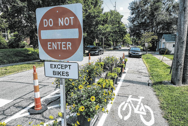
A view of a traffic diverter designed to calm traffic at the intersection of Washington and 17th streets in Columbus, Ind. with a designated bike lane, Friday, Sept. 10, 2021. Mike Wolanin | The Republic
Adraft update to the city’s Bicycle and Pedestrian Plan is now available on the city’s website.
In 2018, the city set out to update its 2010 Bicycle and Pedestrian Plan, said Senior Planner Emilie Pinkston.
Now, after four years of planning and seeking public input, officials have released a draft of the update with hopes for its completion and official adoption in the near future.
The 200+ page draft is available at columbus.in.gov/planning/agendas-materials/ by clicking the link for “City Plan Commission – January 12, 2022.”
The document includes information on current conditions of bicycle and pedestrian facilities, takeaways from public input, different bicycle facility types and recommendations for future projects and improvements.
Pinkston, who is the project manager for the update and the city’s bike pedestrian coordinator, said that residents may be particularly interested in Chapters 7 and 9. Chapter 7 details the recommended changes to the bicycle and pedestrian networks, and Chapter 9 outlines “implementation priorities” for these recommendations.
“This update was initiated to build on the bicycle and pedestrian improvements completed since adoption of the 2010 Plan, to update recommended design standards with current best practices, and to identify how the current network can be enhanced through wayfinding, maintenance, and improved connections,” Pinkston wrote in a memo to Columbus Plan Commission.
She recently presented an overview of the current draft to both the plan commission and Parks Board at their respective meetings.
Bicycle facilities
Since 2010, about 10 miles of bicycle lanes, seven miles of shared use paths and two miles of bicycle routes have been constructed or implemented in the city, Pinkston told parks officials. Pedestrian-activated signals have also been installed in that time.
According to the draft update, the existing bicycle network currently spans 44 miles. The plan proposes updating the network to include 201 miles’ worth of existing and proposed facilities.
Bicycle facilities are broken down into six categories in the plan — shared use paths, buffered bicycle lanes, bicycle lanes, neighborhood bicycle routes, rural bicycle routes and cycle tracks.
Cycle tracks would be a new feature for the network. The update defines these as a facilities that are solely for bicyclists and “physically separated from motor vehicle traffic by vertical elements.”
If all of the plan’s recommendations were implemented, each facility type would increase in mileage as follows:
29 miles of shared use path would increase to 110
0 miles of cycle track would increase to 17
Three miles of buffered bicycle lanes would increase to 6
Seven miles of bicycle lanes would increase to 18
Four miles of neighborhood bicycle routes would increase to 10
Less than one mile of rural bicycle route would increase to 40
The plan does not include sidewalks in its list of bicycle facilities but adds that “inexperienced bicyclists and children are permitted to use sidewalks when no on-street bicycle facility is available or when they are uncomfortable using the provided on-street bicycle facility.”
Recommended sidewalk improvements are included in the draft’s sections regarding pedestrian facility improvements.
Project priorities
The draft breaks down recommended bicycle and pedestrian projects into three categories: Tier 1 (immediate priority) and, Tier 2 (secondary priority) and “Future Projects.” There is also information included on projects that are already underway.
Some examples of Tier 1 project recommendations are sidewalks and a NexusPark shared use path along sections of 25th Street, a shared use path along Washington Street from 11th Street to Rocky Ford Road, a Rocky Ford underpass along the Haw Creek Trail, a downtown connector neighborhood bicycle route, Marr Road street improvements, and improvements to the intersection of Central Avenue and Seventh Street.
Tier 2 projects include, but are not limited to, Gladstone Avenue street improvements, an airport loop trail, a 25th Street east side shared use path from Taylor to Talley Road, a shared use path along Indianapolis Road from Mill Race Park to Lowell Road, and an Abbey Place shared use path extension.
While Tier 1 and Tier 2 both have about 20 projects each, the Future Projects category includes over 80 recommendations. Pinkston said if the right opportunity or funding were to arise, it’s possible that a project listed as Tier 2 or “future” could precede a Tier 1 item.
The document states that the bicycle and pedestrian plan’s implementation should be funded by a variety of sources, such as Metropolitan Planning Organization and City Thoroughfare funds; parks department capital project funds; funding from city entities; federal and state funds as part of highway projects; Federal Transportation Alternatives funds; private fundraising efforts, such as the Columbus Park Foundation; private financing as part of subdivision development; and other funds and grants that may become available.
“This plan serves as a guiding document for future implementation, which will require additional technical analysis as individual projects are pursued,” said Pinkston.
She noted that some of the differences between the update and its 2010 predecessor include an emphasis on “physically separated bicycle facilities,” the creation of a low-stress bicycle network map, new bicycle facility types and terminology, a focus on transitions between different facilities, and an emphasis on branding for the People Trail and general wayfinding.
Officials weigh in
Parks and planning officials reacted positively to Pinkston’s presentation, though there were some additional questions and suggestions.
“I think it’s excellent,” said Parks Board President Mark Levett. “I really applaud the additional shared use paths and the cycle tracks. That’s what the community really needs.”
Julie Abedian, who is a parks board member and liaison to the plan commission, also commended the project and its focus on equity, though she added that there are still additional opportunities to be inclusive. She pointed to multilingual wayfinding as a possibility and also asked about the diversity of stakeholders on the steering committee.
Pinkston said that officials sought to include bicyclists of varying experience and comfort levels, pedestrians, residents from different locations in the community, and individuals of different ages. When asked if there was any diversity of race or ability, she replied that there was one physically-challenged individual who had previously planned to participate in the committee. However, he was not able to attend meetings during the planning process, though Pinkston had a conversation with him about how he uses the network.
City Councilwoman Grace Kestler, who uses a wheelchair, is a member of the steering committee.
“In terms of race, admittedly, most of the committee members were caucasian,” said Pinkston. “I think also, though, most of our applicants were caucasian as well.”
Abedian replied that the community has become increasingly focused on applying equity to various projects and that people are starting to realize that “we unintentionally don’t consider diverse perspectives.”
“It’s not intentional,” she said. “…But we, unintentionally, don’t include diverse perspectives. And I just wonder if there’s way of getting some diverse opinions or perspectives on your plan.”
She added that she has some ideas about how to go about this and that it can be done “pretty quickly and in a productive way.”
In discussing public input on the plan, Pinkston noted that outreach for the project included a open house in 2019, a series of focus group interviews (which included individuals who have physical disabilities), a survey with both an online option and mail-in ballots available from the newspaper, and talking to individuals at a Hot Meals site.
Planning Director Jeff Bergman added that the plan also responds to the needs of neighborhoods identified as having income challenges or other factors of need.
“That thinking was reflected in the last plan too,” said Abedian. “This idea that it’s not just for recreation.”
What’s next
Pinkston wrote in her memo that the update is almost complete, with one exception being an appendix that will be “a standalone guiding document for wayfinding and People Trail branding.”
Officials will work on completing a final draft document of the update for public review, with this likely becoming available on the city’s website in February or March. In addition to the digital file, hard copies will also be made available at some community locations.
City officials plan to return to the Columbus Plan Commission in February or March for a public hearing on the update, further discussion and a vote on the commission’s recommendation to city council “for adoption of this document as an element of the city’s comprehensive plan,” said Pinkston. City council then makes the final decision on its adoption.
However, while approval of the plan update could be just a couple of months away, Pinkston said that putting it into practice will be a much lengthier process.
“Implementation of all the recommended facilities is a long-term effort,” she said. “It’ll take place over many years. It’s a long-term commitment and will likely require phasing.”


