
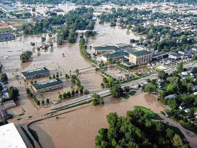
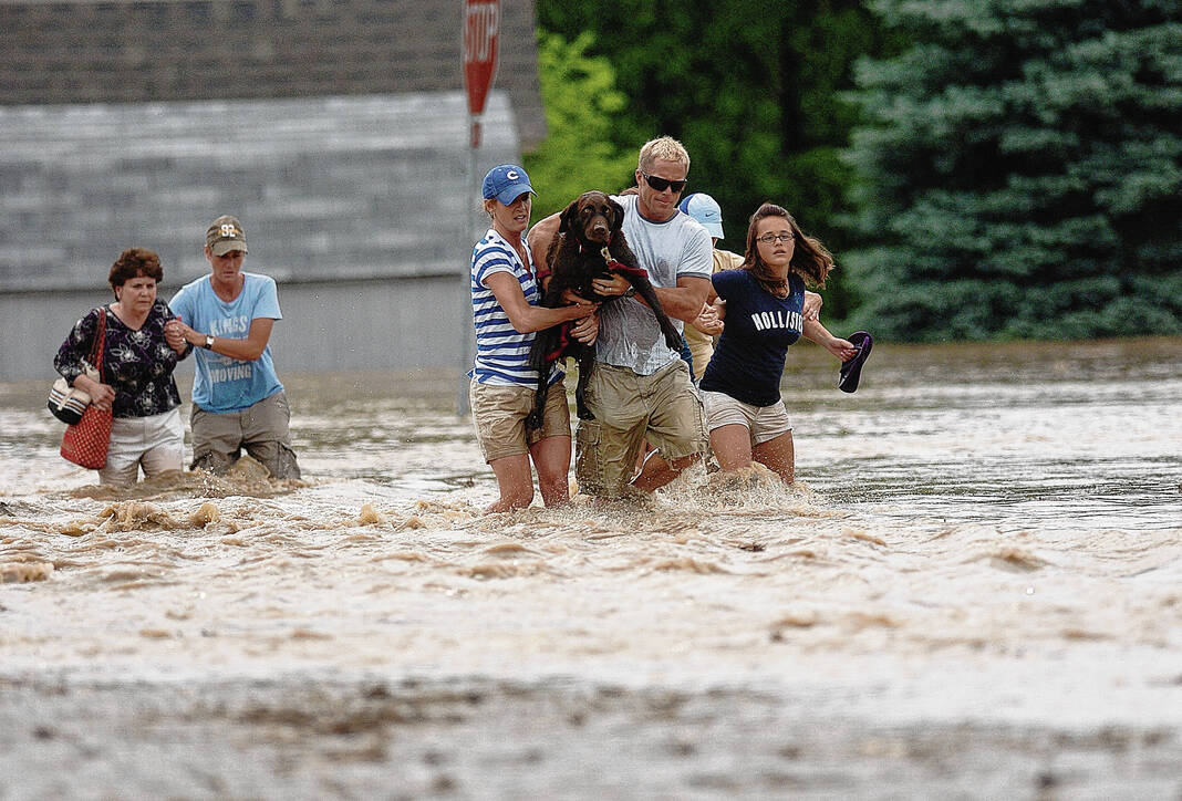
Republic file photo Rescuers and rescued make their way out of the water on U.S. 31 near Wendy’s during rescue operations at Everroad Park West.
Fifteen years after a catastrophic flood devastated the community, local officials say Bartholomew County is still vulnerable to flooding but better equipped to forecast and respond to floods like the one that struck in 2008 largely due to improved planning and communications.
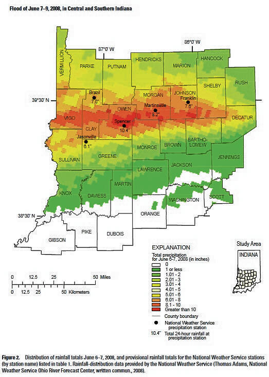
Nearly 15 years ago today, an accumulation of rain over several days had saturated land in parts of 10 counties upstream of Columbus, and on June 7, 2008, more than 10 inches of rain fell into watersheds that flow into the county, adding to a wetter-than-normal spring in central and southern Indiana, according to a report by the U.S. Department of the Interior and the U.S. Geological Survey.
The first signs of flooding in Bartholomew County arrived at 9:40 a.m., when the National Weather Service issued a flash flood alert for the Columbus area. Within the next hour, the Bartholomew County Emergency Operations Center received its first call for a water rescue.
But nobody could have predicted the level of destruction that was heading downstream toward Columbus and the surrounding area.
“I don’t think any of of us quite expected what we got. It was catastrophic,” said Bartholomew County Emergency Management Director Shannon Cooke, who was deputy director at the time of the flood.
Between noon and 6 p.m., the county’s emergency dispatch center was receiving about five calls per minute, according to previous coverage in The Republic. That number rose to nearly seven calls per minute from 6 p.m. to nearly midnight.
“It was hectic, fast-paced and chaotic,” Cooke recalled.
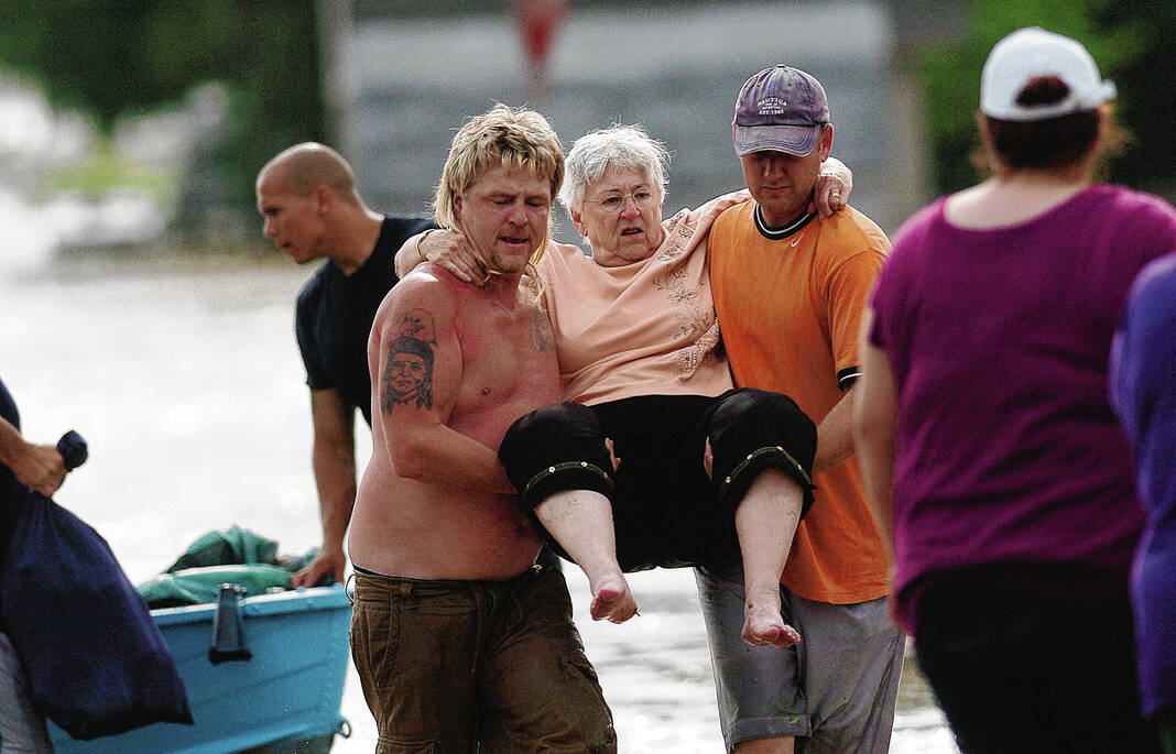
Overall, the flood caused more than $500 million in damage, claimed three lives and left an indelible mark on Bartholomew County — and its impact is still being felt today.
On June 8, 2008, former President George W. Bush declared a major disaster in Bartholomew County and other communities impacted by the flood. Of all the communities included the disaster declaration, Columbus was the hardest hit, according to the report.
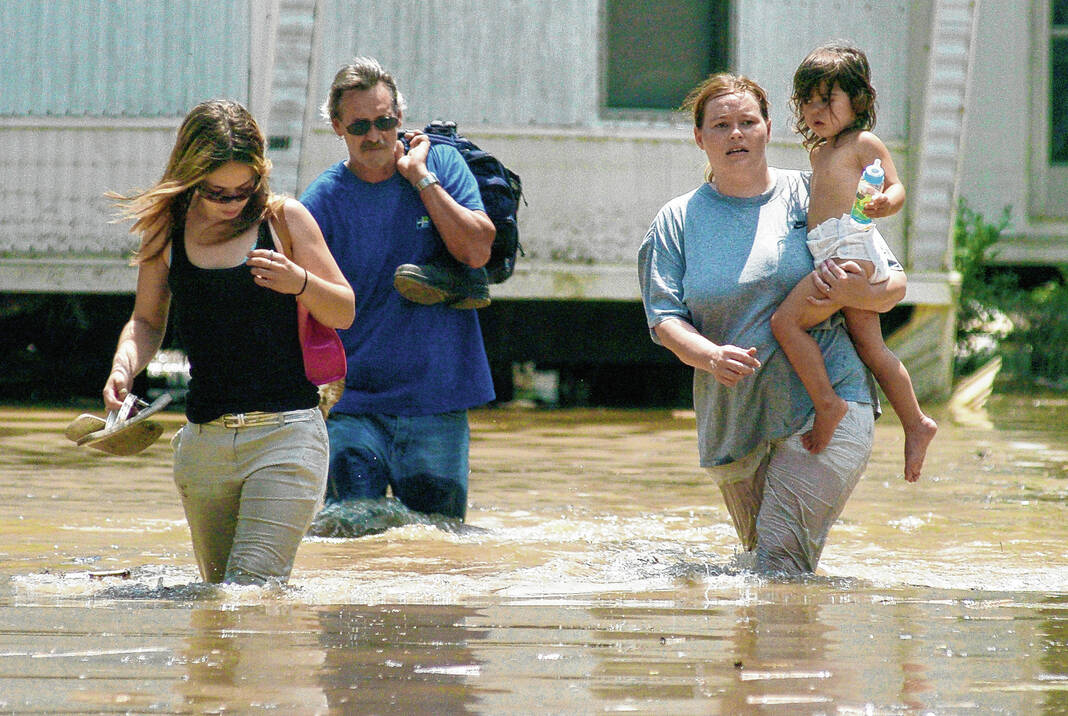
Roughly 2,8oo homes were damaged by flood waters in Bartholomew County — including 15% of all structures in the city — and 1,000 local residents were evacuated from their homes and placed in shelters. More than 70 businesses in Columbus sustained flood damage.
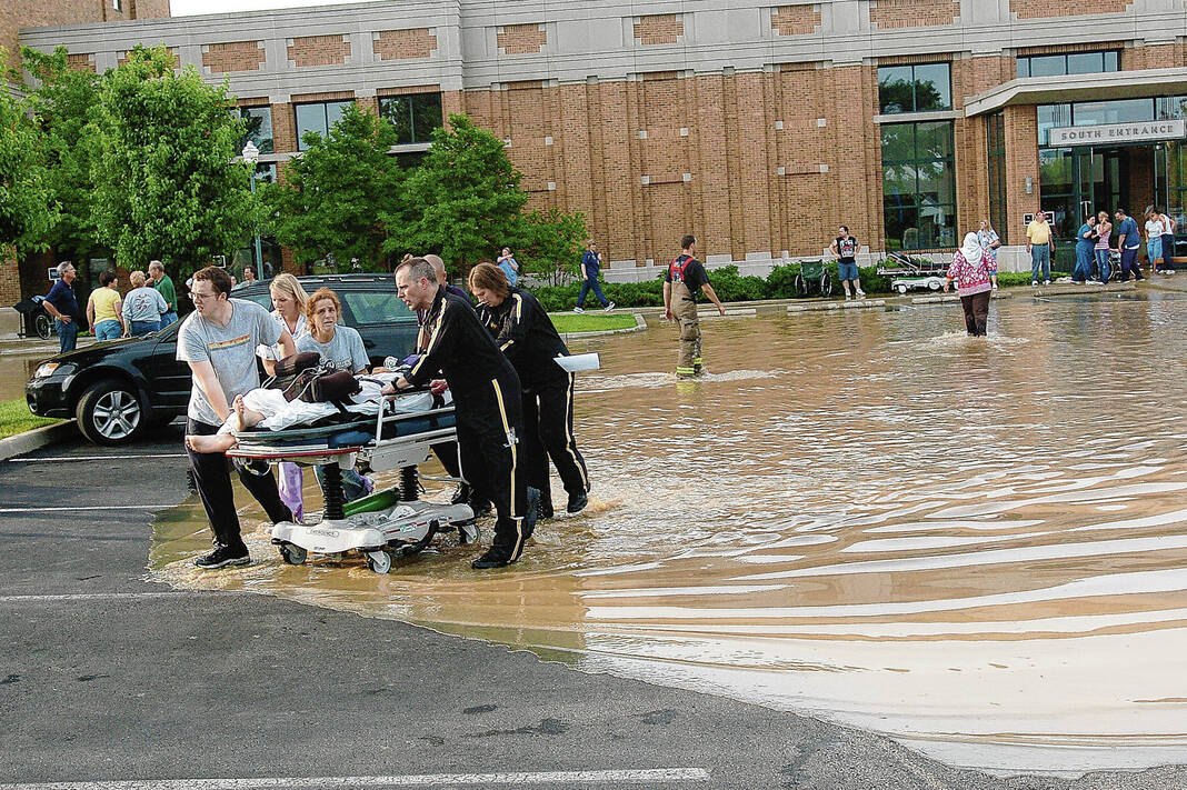
At the same time, flood waters knocked out primary and emergency electrical systems at Columbus Regional Hospital as water from Haw Creek poured into its basement and quickly rose up elevator shafts and stairwells, covering the first floor of the hospital in roughly 6 inches water, according to the Federal Emergency Management Agency (FEMA).
Staff scrambled to evacuate all 157 patients, remove vital equipment and were forced close the hospital’s doors for the first and only time in the facility’s 106-year history.
Members of the Indiana National Guard helped hospital officials carry patients down flights of stairs to be transferred to nearby hospitals. CRH Chief Medical Officer Dr. Tom Sonderman recalled that two babies who were in incubators in the hospital’s special care nursery were among the last to be evacuated.
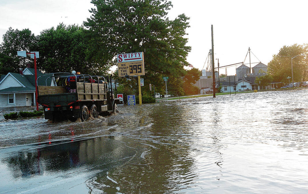
Floodwaters engulfed nearly all roads into and out of Columbus, largely isolating the city from nearby communities. By mid-afternoon on June 7, 2008, Interstate 65 and U.S. 31 to and from Columbus had been shut down.
“That’s the worst of the worst,” said CRH Vice President of Strategic Facility Planning and Operations Dave Lenart. “Everybody always thought that it would never happen. It’s like when pigs fly.”
Planning
Bartholomew County lies at a point where several bodies of water — the Driftwood River, the Flatrock River, Clifty Creek and Haw Creek — converge to form the East Fork White River.
About 2,000 square miles of upstream land drains through Columbus and Bartholomew County, which continues to make flooding one of the most significant natural threats to the area.
But the extent of the flooding along Haw Creek during the 2008 flood was somewhat unexpected and was more severe than predicted in maps drawn up by FEMA, officials said.
Following the flood, the city, CRH and Cummins Inc. partnered to fund their own floodplain study of Haw Creek, “which is a relatively unique thing for a local community to undertake,” said City/County planner Jeff Bergman.
“Usually, that’s kind of exclusively a domain of FEMA,” Bergman said. “…A big takeaway for us after 2008 is the city with a couple of community partners developed their own floodplain map for Haw Creek in order to have something that was more accurate than FEMA’s mapping.”
FEMA also embarked on its own remapping of Haw Creek, which just concluded this past spring, Bergman said.
Additionally, city officials decided to increase local regulations governing the most sensitive part of floodplains and protect the area from development “to make sure that (the) floodplain and floodway continued to function as it does naturally,” said Bergman, whose department is responsible for administrating floodplain regulations for new development in the community.
At the same time, local officials have added stream gauges along the major bodies of water, including Haw Creek, where there were no flood gauges at the time of the 2008 flood, Cooke said. The gauges measure the water level in several creeks and rivers in the county and give officials advanced warning of a flood event.
Currently, there are eight stream gauges in the county, including three in Haw Creek, two in Clifty Creek and one each in the Driftwood River, Flatrock River and East Fork White River. The three gauges in Haw Creek are located near Hope, Clifford and the east side of Columbus.
“We did not have as many prior to the flood,” Cooke said.
The gauges work in conjunction with the county’s flood response emergency plan, which was put into place in 2012 and has been tested with extensive exercises that year and, at a minimum, every three years. “(The gauges) kind of give us that heads up that says, ‘Hey, here are the water levels,’ and those levels guide the action items within the flood response plan,” Cooke said.
“When it does flood, we do reference that document,” Cooke said.
Officials said they were unable to conduct exercises during the COVID-19 pandemic but are hoping to hold another exercise within the next year.
Floodwall
Following the flood, CRH constructed a $4.7 million floodwall around the hospital campus with the help of FEMA to prevent future flood damage. The floodwall was built 2 feet higher than the 100-year flood elevation and includes 15 floodgates at entry points to the hospital campus.
During the immediate aftermath of the flood, the hospital’s doors remained closed as officials renovated and repaired the basement and first floor of the hospital, Lenart said. Some “mission-critical departments” were located in the hospital’s basement at the time of the flood, including the data center for the hospital’s computer systems, pharmacy and labs, Sonderman said. Those were all moved to safer locations.
A mobile emergency unit from North Carolina opened on the hospital campus two weeks after the flood to resume 24/7 emergency services in Columbus. Up until then, people in Bartholomew County who needed emergency medical care were transported to facilities in other counties, officials said.
An interim emergency department was able to open within the hospital building six weeks later. And on Oct. 27, 2008 — less than five months after the flooding — CRH opened the doors to its new and improved facility and continued
“Now everybody probably takes a little different view towards risk management and how things are being understood or at least being planned for in the event of the worst,” Lenart said.
Flood-prone areas have become part of the hospital system’s strategic planning process, officials said.
The potential for flooding factored into CRH’s decision to acquire 700 acres of land on the west side of Columbus, officials said. CRH and the city of Columbus recently unveiled a concept to turn the site into a community that includes not only a new hospital campus, but also housing options, various types of developments and a great deal of green space.
Hospital officials previously said the potential for flooding played a role in the acquisition of the former Clarion Hotel and Conference Center on Jonathon Moore Pike on the city’s west side.
“This site (the 17th Street campus) proved itself as being vulnerable to flooding,” Sonderman said. “…That did play into the decisions on future expansion and the future of the health system.”
“That is a definite lesson learned,” Sonderman added. “…It is a vulnerability in our community because (with) the confluence of waterways in Columbus, you have to be very deliberate about building sites.”
Communication
If another major flood were to occur, local officials also said they have better tools to inform residents and give instructions on what they should do, including in the event of a flash flood like the devastating one in 2008.
The biggest addition came about 10 years ago with the implementation of the city and county’s Everbridge system, which allows messages to be sent to residents by phone, text and email, Cooke said. It also allows officials to send mass notifications internally to first responders, elected official and others about briefings.
Additionally, Cooke said local officials have tried to educate the public on what a flash flood is and what to do in the event of one as “we had a lot of residents who honestly sat and watched the water get closer and closer and didn’t evacuate when they should have.”
While officials said they are in a better prepared to respond to a catastrophic flood than 15 years ago, they said that memory of the 2008 flood will loom large for years and years to come.
“It’s just always there,” Cooke said of the 2008 flood. “It’s another flooding event, but it’s our marker. At least within the last 20 years, that’s the most significant flood that we’ve had in this area.”
“(The 2008 flood) still plays a part (in our preparations), she added. “It’s probably going to for years to come.”


